Nearby Trails
La Luge
Overview
This is the Reason For The Ride. It's a twisty, technical downhill plunge
through the jungle that might just make you want to do the climb all over
again. Watch out for hikers if you're alone or the first in your group,
especially near the end of the trail where there are several interesting tombs
and caves. The top section is quite difficult for most of us mortals;
very narrow with lots of roots, drop-offs, and few (if any) clear lines. You
can get through it reasonably well if you're willing to sacrifice your upper
body a bit (ok, you have to ride it at least once to understand...) and lay
off the front brake. The rest of the trail alternates between very narrow
convex and very narrow concave in cross-section; one minute you'll be in a
half-pipe with walls over your head and the next you'll be looking at a
50-foot dropoff on either side of you. It's always a rush.
The Trail
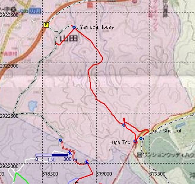
From the observation tower there's a trail that heads sharply down the back (southwest) side of the hill (facing the Hawk missile site and Yomitan). At the bottom of this section (about 30m) the trail turns sharply back and to the right.
Don't miss this turn! It could hurt...alot. There's a sign at this point that says "La Luge - Watch For Hikers!". The remainder of the trail is single-track all the way to the bottom, with no obvious way to get lost. You'll know you're near the end of the trail when you emerge from a small bamboo thicket and get hit in the face with a spectacular view down the west side of the island. Don't stare longer than a half-second or you'll be off the trail. About 100m past this point you'll plunge back into the jungle and the surface becomes extremely rough. Don't crash here - it's all coral & limestone. A hard left turn at the bottom of this section carries you out of the jungle, where there's a house and a few signs, all in Japanese of course.
From the house you have several choices as to where to go. Here's just one way:
Follow the trail behind the house until you come to some stone steps, about 50m. Carry your bike up the steps, then follow the trail straight ahead and around a sharp right turn, down to the road. (Just past the top of the steps is another set of stone steps that lead down to the right of the trail. Hardcore folks ride down these steps and continue down the short steep trail to the paved road. I don't recommend doing this without somebody to watch for traffic at the bottom. In fact, I'm too wimpy to try it at all, but many others have, and survived, and had fun on all accounts...) Turn left on the paved road and climb until you reach a T-intersection, about 200m.
If you turn right at this point then you'll wind up on Route 58 in very short order. You can follow this all the way back to the parking area if you like. There are a couple interesting diversions along the way, but the best way to find these is to have somebody show you where they are, or to discover them for yourself.
If you turn left at the T-intersection then you'll continue on the paved road past some gravel piles and a concrete mixing plant, around a sharp left bend and up a reasonably steep hill. When you reach some high-tension power lines there will be a dirt road leading off to the right - it deceives you at first with a short, relieving downhill, but quickly turns into a mean little uphill grind called Heartbreak Ridge on loose terrain. (If you follow the paved road around a left-hand bend and beyond the power lines then you're either going too far or perhaps just finding your own way).
Follow this until there's a trail to the right, about 300m (if you're measuring this then bear in mind that this one's a big "guesstimate"). Take that right turn uphill and there's another right turn that leads down hill for a very long way. That's The Mother.
If you want to skip Mother, bear left up the rest of the road and follow it as it winds through a tree-line. It'll end at a sharp turn right down a "path" that hasn't seen traffic in quite a while, look for a hole in the brush on the left, follow that until to the High Road
La Luge Bypass
Overview
If you've at least tried the top section of La Luge more than once and decide
that's it's just not your bag (or maybe you just don't want to climb
those stairs, you girly-man you), then you can take the way around the nasty
stuff that still lets you enjoy the ride on the bottom part.
The Trail
Instead of climbing the stairs to the observation tower, look for a dirt road
to the left where the paved road turns sharply to the right, just beyond the
picnic area. Follow this road until you see a trail to the left, about 200m. (The
road continues on for a fair distance beyond the turn, paralleling Rte. 58).
The trail takes a short downhill dip, then climbs up to the right, twisting a
couple times until you reach a clearing around the base of a high-tension
electric tower.
Cross the clearing and look for an opening in the brush to the left. The trail is very narrow and twists sharply, affording many opportunities to become closely acquainted with the vegetation. The end of this short section opens onto La Luge, just beyond most of the root-infested endo-inducing stuff.